Touring the Custer Area – Wind Cave and Jewel Cave

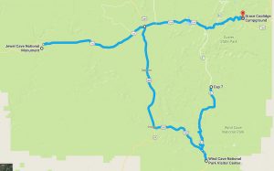
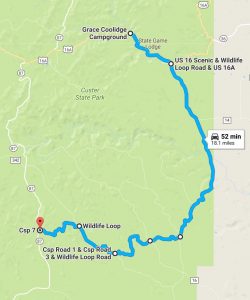
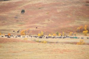
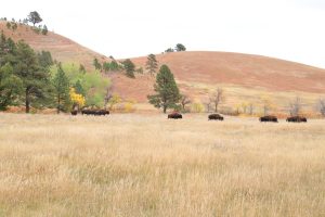
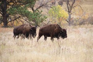
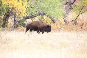
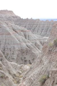
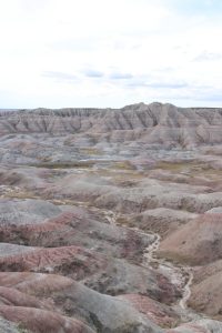
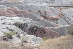
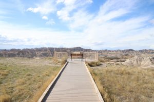
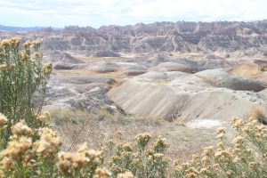
As we left the Wildlife Loop Road, we headed south on Hwy 87 towards Wind Cave National Park. Seeing that Kathy had her Passport, we figured we’d take the opportunity to get a couple more cancellations – one at Wind Cave National Park and a second at Jewel Cave National Monument. Both parks were in range and the drive would give us an opportunity to see more of the Black Hills.

The caves in Wind Cave are reportedly some of the world’s oldest caves initially forming over 320 million years ago. They were formed through the eons by combinations of erosion, upheaval, and more erosion. Found by settlers in 1881, the complex cave system in the park includes over 100 miles of explored passages. Barometric wind studies, however, estimate that only 5% of the total cave has been discovered.

After our visit to Wind Cave, we headed out to another cave area, Jewel Cave National Monument. Jewel and Wind caves are about 20 miles apart “as the crow flies”, about 30 miles by car. Neither of us had ever been to Jewel Cave so we had no expectation for what we would find. Quite honestly, I kind of figured it to be the “poor step child” to Wind Cave. Nonetheless, the stop would provide Kathy with another cancellation in her passport for the national parks and monuments.

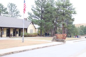
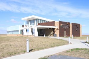
We found the road to Jewel Cave on Hwy 16 just west of Custer. The sign and road were unassuming and led to the site’s visitor center. Kathy got her passport stamped and we decided to visit the small museum to find out more about the park.

It turned out the story about the park was fascinating!

Much like the companion Wind Cave, settlers stumbled on Jewel Cave in the early 1900’s when two miners found an entrance that was too small for people to enter with a blast of cold air coming out. They  proceeded to open the entrance and investigate the cave, finding low ceilinged rooms coated with “jewel-like” crystals. The commercial value of the “jewels” was low, but there were attempts to develop the cave site as an entertainment and amusement center.

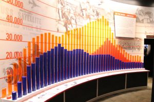
The attempts weren’t successful, and the two miners eventually sold the claim back to the government and in 1908, the cave was proclaimed a national monument by Teddy Roosevelt. Development was slow until 1959, with approximately only two miles of the cave discovered and mapped. With questions of the significance of jewel cave being raised, a geologist who enlisted the aid of wo rock climbing enthusiasts embarked on a more dedicated exploration. By 1961, the discovered and mapped length was 15 miles. The discoveries led to more investment and interest in the cave system into the early 1970’s.

Exploration has continued, and today jewel is the third longest cave in the world with an explored length of just under 192 miles to depths of 830 feet. The museum includes a painted mural that shows the extent of the cave system.

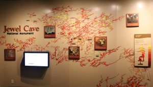
Because the structure and development of the cave is like Wind Cave, there is speculation that the two caves may be joined and exist as a single cave. My impression of Jewel Cave being a poor step child to Wind Cave was totally blown out of the water by this visit.

We didn’t have a chance on this trip, but maybe in our future travels we’ll have a chance to do a bit of spelunking in the caves underneath the Black Hills.

Touring the Custer Area – The Wildlife Loop

Custer State Park started as a game preserve and the Wildlife Loop Road was one of the first roads laid out in the park. The drive goes in a circle through the open grassland and rolling hills nestled high in the Black Hills. The road is deliberately laid out in the area most likely to provide sightings of many of the animals for which the park is famous. The best part of the Wildlife Loop is the fact that it will most likely be different each time you visit – because the animals roam freely through the park, there are no guarantees and each hour of each day could be different than the last..

We weren’t too sure what we’d see on our wild life drive, since Custer had just conducted the annual Buffalo Roundup the Friday before. Each year, the park herds all their buffalo into corrals for inspection, shots and culling. Within days, the herd is released a bit at a time to return to their grazing land. Since we were so close to the roundup, we weren’t sure how many buffalo had already been released.

Not too surprisingly (considering the season), the road wasn’t very busy and we cruised slowly watching for signs of animals. It didn’t take too long before we found Pronghorn Antelopes casually grazing near the road.

Just before we reached the halfway point on the loop, we decided to take a gravel road turnoff (Old Draw Road) that we thought would give us a chance to get an overview of the buffalo corrals. The quiet road was better than we could have hoped! We found a spot to park that gave us a great overview of the corrals as well as a chance to take a walk with Tyler and simply enjoy the quiet in the middle of Custer.

As we continued along the draw, we found ourselves getting closer to the corrals and the buffalo moving to the open range. We had a great chance to watch the herd walking through the pines along the edge of the corrals under the watchful eye of the lead bull.

As we neared to point where the draw rejoined the loop, Kathy noticed an interesting artifact in the grasses close to the road – she found a buffalo skeleton and skull lying in the open.

Just as we approached state highway 87 to head towards Wind Cave, we ran across one last bit of wildlife – a flock of turkey’s rummaging alongside the road.

Days 4 and 5 – Touring the Custer Area

Custer State Park is one of the nation’s largest state parks at 71,000 acres and just a couple of days are barely enough time to just scratch the surface in terms of what the area has to offer. Every road is a scenic panorama and the area is loaded with wild life. Besides the state park, there is also one national park and two national monuments in the immediate vicinity of Custer. The area is also sprinkled with numerous small towns, all of them quick to invoke their western and mining heritage with attractions, tours, and shops.

For our first full day in Custer, we planned to “take a ride on the wild side”, starting with the Wildlife Loop and then tour to Wind Cave and Jewel Cave to give Kathy a chance to get some more stamps in her National Parks Passport book. For our second day, we planned to do a couple of the scenic drives that Custer is noted for and make a stop at Mount Rushmore so Kathy could get one more stamp.


Day 3 – Through The Badlands And Beyond

Our third day of travel was going to run longer even though it was one of our lower mileage days. After checking out of our hotel in Oacoma, we headed west on I90 towards the Badlands and Custer State Park. Our plan was to take the scenic drive through the Badlands and then head towards Custer, where we had a campsite reserved for three nights. After our stop at the South Dakota Information Center, we added one more stop for the trip – the Minuteman Missile National Historic Site just off the interstate at the Badlands exit.

The Minuteman Missile National Historic Site is a relatively new National Historic Site having been established in 1999. The brochure piqued our interest since we were both kids during the Cold War (“duck and cover” instructions, air raid drills, bomb shelters, and, yes, missile silos). A planned quick stop at the Visitor Center turned into about a 45 minute walk through a very impressive museum display documenting the Cold War and explaining that the plains was dotted with missile silos because of the ability to strike the USSR directly and quickly by firing nuclear warheads on Minuteman II Missiles buried in underground silos all across the Great Plains. The visitor center was just the introduction to the real highlights of the National Historic Site – a restored underground missile launching bunker (open for tours, but not able to be scheduled on the day of arrival) and a restored missile silo that could be viewed from above ground. The additional sites were in two different locations over the next 15 miles of interstate and we didn’t make the stops, opting for the Badlands instead.


If we make it back, we’ll plan for the stops (probably spending more time in the Badlands as well). While at the store, Kathy decided to pick up a National Parks Passport and got her first cancellation. Now that she has the passport, our trip plans will be changed a bit to include more stops at National Parks, Monuments, and Historic Sites so she can maximize the number of cancellations she gets on this trip.

Running behind to our rough schedule, it was off to the Badlands. Before entering the park, we stopped at a gas station/convenience store, filled up the tank and bought some sandwiches and drinks for lunch along the drive through the park.

Entering the park, Kathy bought an annual senior pass for $20 that will cover all our park admissions this trip; we figured if we paid the “per vehicle” charge at each place we planned to go, it would be $40 so the annual pass was a bargain. (Twas a shame we didn’t get our permanent Senior passes before the trip…oh well…they’ll probably be there when we get home!)

First stop after paying our entrance fee was the Ben Reifel Visitor Center so Kathy could get her National Parks Passport stamped and we could learn a bit more about the park.

The Badlands started to form millions of years ago as a variety of rock layers were deposited on the exposed plains successively through the eons. About a half million years ago, the deposition process slowed and erosion took over. “Modern” rivers cut through the rock layers, somewhat selectively based on the type of rock, carving intricate shapes, canyon walls and pinnacles that draw visitors to the park today. What was really interesting is that the Badlands are eroding rather rapidly, about an inch a year. At this rate, the Badlands will erode completely away in another 500,000 years. It may be a good idea to see them before they disappear!

With all of our new found knowledge, we headed out on Badlands Loop Road, a 40 mile ride through the park.

The Badlands is immense and at first just seems to be a lot of the same scenery, but when you take the time to really look at the rock formations and notice the layering and differences in erosion, the rocky landscape provides a humble introduction to the forces of nature, especially water and wind. We traveled the road just after noon and the sun was high, but stopping to look into the shadows and scanning the landscape as clouds passed, shading the sun, suggested that a single scene could take on all new dimensions depending on the time of day.

Tyler seemed to enjoy the landscape as well, demonstrating his rock climbing ability.

We stopped and ate our lunch at Bigfoot Pass overlook. It was sunny, but the temperature was great, mid 60’s. The wind was strong, though, so we had to be careful that our lunch wouldn’t blow away. Tyler again enjoyed an escape from the car and we took a short walk to take in the views from the overlook.

After lunch, we continued our drive through the badlands, stopping a time or two to take in the views before we continued our drive to Custer State Park and the camping experience of our trip.

We rejoined I90 at Wall South Dakota, making a quick drive through town to drive past the infamous Wall Drug. It was a bit late in the day and we were anxious to get camp setup before dark, so we decided to leave a visit to the iconic travel stop for another time.

We arrived at Custer just a bit before 5PM and made a quick stop at the Camp Store to pick up some wood for a fire just before they closed. We pulled into our camp ground and found our site. As we unloaded our gear to setup camp, we watched a flock of big horn sheep as they nibbled on acorns in the camp ground.

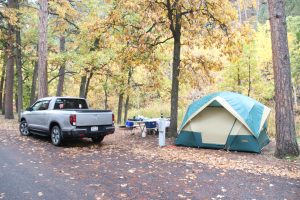
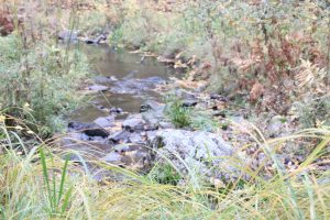
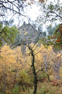
 The camp ground was quiet, about two thirds full. Our site wasn’t overly large, but it was adequate, bordered on the backside by a small creek. Across the creek was a large rocky wall.

I’d find out the next morning that there was a wildlife trail winding down the rocky wall when the big horns returned for breakfast!

It had been a long day and after a quick camp supper we climbed into bed It was a cool (almost cold) night and it rained a bit. Still, we slept good and our gear kept us warm.

Days 1 and 2

The goal for the first two days was to get across Wisconsin, Minnesota, and half of South Dakota, not necessarily as fast as possible, but without a lot of stops. Our first night was planned for Albert Lea Minnesota and our second night was planned for Oacoma South Dakota.

We were cruising pretty good through Wisconsin when we decided to break our “side trip” rule. I saw signs for the Elroy-Sparta Bike Trail and told Kathy it would be nice to see what kind of hotels and motels were available if we did the trail next year. Off we went down WI 80 to Elroy, then along WI 71 to Sparta. We found one quaint motel right along the trail (stayed there once before many years ago when we did the trail with the kids) and a couple of others to consider. We also found out there are quite a few places we could consider right in Sparta. Our little detour cost us about an hour and a half, but it was fun having the time to say, “Let’s do it!”

Lunch was “on the road” at a wayside. Kathy likes to make a simple carry along lunch – this time a blend of tuna, cream cheese, walnuts and water chestnuts that we spread over crackers. The spread, some grapes and a cold drink was enough to keep us until supper.

We pretty much cruised the rest of the way, getting into Albert Lea about 5PM.

Day 2 was a straight shot across the second half of Minnesota and the first half of South Dakota. Not too much to see along this part of the route except vast fields of corn, wheat and soybeans. Still, the size of the fields is awesome when you consider the amount of food and food products that is produced on this land.

We did manage to find the Badger game on SiriusXM and that helped the drive time go fast. GO BADGERS! We also made a stop at the first rest area as we entered South Dakota to load up on brochures and maps. At the rest area, the gent behind the counter suggested we make one last stop just before getting to the hotel in Oacoma to visit the rest area on the east side of the Missouri River.

The stop was well worth it. The rest area is located on a high bluff overlooking the mighty Missouri, offering great views of the lands to the west. They also have a great museum display on Louis and Clark and their journey through South Dakota as they searched for the western passage. But the real star of the rest area is a fifty foot stainless steel statue of an Indian woman cloaked with a star quilt. The statue is named Dignity: Of Earth and Sky and was created by the artist to represent the “courage, perseverance and wisdom of the Lakota and Dakota culture in South Dakota”.


Tonight will be at a hotel in Oacoma, and tomorrow we head across the Missouri to Custer State Park through the Badlands. Then our camping adventure begins!

The Inaugural Retirement Trek

South Dakota – Colorado – Nebraska

With the final decision on retirement made, it‘s time to take a trip. The original plan was to do all of Route 66 as soon as I retired, but things came up and my retirement came later in the year than we expected and traveling this late in the year with the convertible just made no sense. (Route 66 is going to have to wait until next year!).

We decided to head to Colorado to visit the kids but do it in a way we couldn’t do before. Going out, we plan to go through South Dakota and make it a six-day trip out. We’ll take seven days in Colorado, but that will include at least a three-day (including drive days) side excursion to the Colorado Springs region. Coming back, it’s a slow-paced trip, including a slow scenic drive through Nebraska to see what the state can offer. No reason to rush!

All in all, the Inaugural Retirement Trek will be a twenty-day trip (longer than any vacation we’ve been able to take while working) and a good way to break into the longer trips we want to take now that we’re retired.

Let the adventure begin!